|
Navigation
Methods - How We Get From Here to There
In Navigation Tools we describe the
charts, compass, sextant, and GPS and how they relate to the grid
of latitude and longitude lines that cover the earth. These tools,
together with an understanding of Universal time, help us determine
exactly where we are. Once you have an understanding of the navigational
tools, you can begin to learn about navigational methods, or how
to use these tools.
In this section we more thoroughly discuss the various methods
we can use to pinpoint a specific geographic location and plot
our position. These methods include:
After reading these sections, test your mastery of these topics
with the exercises!
Dead Reckoning
Often, we are sailing the boat within close sight of land. When
doing so, we can see the features on land and identify those features
on the chart. In this case, it is very easy to navigate.
If we want to be even more precise, or if we can see land but
it is still a ways off, we can use our compass to help determine
exactly where we are. With our boat's compass, or even better,
a handheld compass, we can take the magnetic heading or "azimuth"
from our location to a distinctive land feature near the shore.
This feature could be a rocky point, a lighthouse, a mountain,
a cove, or anything that is distinct in our sight and is shown
on the chart. We then compute the "back azimuth" by adding 180
degrees (if the azimuth is less than 180) or subtracting 180 degrees
(if the azimuth is greater than 180). We then draw the back azimuth
on the chart from the feature on shore with a pencil. Now we know
that we are somewhere on that line.
Then we identify a second object on the shore and repeat the
process, drawing a second line on the chart. Where those two lines
intersect is very accurately where we are located on the chart.
To verify our measurements, we will repeat the process a third
time. The third line on the chart should intersect the first two
lines at almost the same point. This is called a "triangulating
position." Because the boat is always moving, the three lines
will never really intersect at the exact same point, but they
will be very close.
The three lines will form the sides of a small pyramid or triangle.
We then mark a dot in the center of the triangle and measure the
latitude and longitude of that center dot to identify our position.
We always write the date and time down on the chart when we mark
our position.
We can then steer the boat on a compass heading in a straight
line to where we want to go from our present location, now that
we know where we are on the chart. If we wait a while and triangulate
our position again, we can measure the distance between the two
marks and find out how far we have traveled. Since we know how
long it took us to cover the distance, we can also calculate our
average speed.
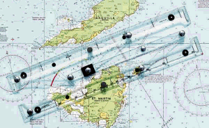
Parallel Rules on Chart 
Unseen Currents and Dead Reckoning
Often we encounter unseen currents in the ocean. Also, while
the wind pushes a sailboat forward, it can also push us off course.
This is known as "set and drift." If this happens, our
second position will show us that. If we have been traveling forward
on a specific heading, our second position should show us on that
same heading on the chart. But if our second position shows that
we are not on that same heading, then we know that we are being
pushed off our course by the wind or a current. Once we know we
are being offset from our intended course, we can deliberately
steer a course to counteract where the current and/or wind is
pushing us. Depending on the amount of set and drift, or the strength
and direction of the wind current, we may have to steer many degrees
off our map heading to go in the direction we want to go!
There is another situation when we may intentionally steer off
our course. If we are heading into port (into a harbor) and we
are still too far from shore to identify features on land, we
will intentionally steer slightly to the left or to the right
of where we want to end up. This way, when we do come within sight
of identifiable features on land, we know to look in the opposite
direction for our destination. This is called a "deliberate offshoot"
and it makes finding our destination a bit easier.
Calculating Speed with Dead Reckoning
Remember from Navigation Tools that
each degree of latitude consists of 60 minutes. Each minute is
equal to one nautical mile or one "knot". So if we traveled a
total of 30 minutes of latitude in 5 hours, we are traveling at
an average speed of 6 knots. While that may not seem very fast,
it is actually the average speed for a boat Landfall's size!
The most dangerous time on a boat is when the boat is close to
land. As you grow closer to shore, the water becomes shallower
and the likelihood of hitting a reef or running aground increases.
In many countries these near-shore hazards are marked with aids
to navigation, such as buoys and lights. Unfortunately, unless
you understand what all of the aids to navigation mean and how
to use them, they offer no help. Many of these aids are unlit,
so at night the very items placed to assist you become hazards
themselves!
As you approach land you are also much more likely to encounter
other boats. Just like on the highway in your car, there are "rules
of the road" which must be understood and followed by everyone
to avoid collisions. Also, boats and ships do not have brakes
like cars do, so extra care must be taken to stay safe. Generally
speaking, we prefer to approach land during the daylight to minimize
these risks.
Global Positioning System (GPS)
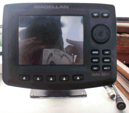
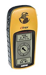
Deck Mount GPS  Handheld GPS
When navigating with a GPS there is not much need for dead reckoning.
However, when we are near shore, we often use the dead reckoning
method along with the GPS, just to stay in practice. Also, in
the event that for any reason the GPS stops working (like a power
failure or dead batteries), we can still navigate easily and safely.
But GPS really shows its value when we cannot see land or any
other navigational aids. This can happen when we are far offshore,
but it can also happen when it is dark, rainy or foggy.
The GPS works on the same principle as the triangulation process
we described above. The only difference is that instead of using
a feature on the shore, the GPS uses signals from three or more
satellites in "geosynchronous" orbit around the earths. In other
words, the satellites maintain the same position in relation to
the Earth's rotation in their orbit. There are twenty-four of
these satellites in constant orbit around the earth. The GPS receiver
on the boat takes the data from these satellites to triangulate
its exact position on earth. Once the GPS has picked up the signal
from at least three different satellites, the computer chip inside
does all of the work for us! Our only task is to learn which buttons
to push to make it work.
The GPS display then shows us our position in latitude and longitude,
the direction we are traveling, and the speed we are moving. Even
though this is done electronically, we still plot our position
on the paper chart every couple of hours in case the GPS loses
its memory or power.
In the days of the sextant, it was very difficult to get a good
measurement on overcast days or in rough seas. The GPS works day
or night, regardless of the weather. Because this tool is so valuable
to our safe navigation, we always carry a handheld GPS as a backup.
|
![]()