|
Navigation
Tools - Getting Us From Here to There
Unlike when driving a car, there are no roads or highways marked
on maps of the seas and oceans. So how do we know where we are
and where we're going, especially when we can't see land? Well,
we have to navigate. Navigation is the science of working out
the position of a vessel (or airplane or missile, for that matter)
and charting a course for guiding the vessel safely from one point
to another. A navigator usually tries to find the shortest route
between two points. The initial planning and the end results of
navigation are plotted on charts. Most of the navigable waters
of the world have been surveyed accurately by the hydrographic
services of the maritime nations and reliable charts of the waters
are usually available.
In addition to charts, here are other tools we can use to help
us navigate. Landfall's navigation tools include:
After reading these sections, test your mastery of these topics
with the exercises! Once you have an understanding
of the navigational tools, you can begin to learn about navigational
methods, or how to use these tools.
Charts
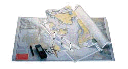
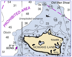
On a vessel we carry special maps called "nautical charts." These
provide a "to scale" representation of the navigable waters, landmasses,
and "aids to navigation". Aids to navigation are the buoys, lights
and radio beacons placed along the coastal waterways to make navigation
easier in confusing or dangerous waters. These charts also show
the "relief", or the elevation of landmasses and the depth of
oceans and waterways. This clues us in to the terrain on shore
as well as on the sea bottom. Latitude and longitude lines are
also shown on the chart. This allows us to relate what we see
around us to our specific coordinates. Once we know how to use
our navigational tools, the latitude and longitude lines, together
with our charts, serve as our sea "street signs".
Compass Navigation

The compass rose similar to the simple one above has appeared
on charts since the 1300's. The term "rose" comes from the figure's
compass points resembling the petals of the well-known flower.
Originally, this device was used to indicate the directions of
the winds (and it was then known as a wind rose). This compass
rose shows the directions of the eight major winds. (There are
32 points of wind shown on a full compass rose.)
Our ship's compass shows us this information about our direction
in relation to "magnetic north". The compass is divided
into the same basic points, but a magnetic compass tells us which
direction is magnetic north and from that we can tell which direction
we are going. Because the compass is mounted in the cockpit directly
in line with the bow of the boat, when we are standing at the
helm, we can look down at the compass and know exactly in which
direction the boat is headed. (In the picture below, the compass
is headed "due north".)
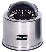
A compass is a circle made up of 360 degrees. Every 90 degrees
represents a different cardinal direction. North is 0 degrees,
and no matter which direction you are going, the compass always
points to magnetic north. Going clockwise from north, East is
90 degrees, south is 180 degrees, and west is 270 degrees. So
just by looking at the compass, we can tell which direction we
are going. But that doesn't help much unless we know where we
are in the first place. And a good chart really helps, too, but
in the middle of the ocean with no land anywhere to be seen, a
map and compass are not enough. What else do we need?
Latitude and Longitude

Any location on Earth can be described by two numbers: its latitude
and its longitude. If you look at a map or globe of the earth,
you will see that the planet is divided by equally spaced horizontal
lines that run around the earth like a series of parallel belts,
and another set of lines the run vertically, up and down from
the two poles. If an airplane pilot or a ship's captain wants
to specify position on a map, latitude and longitude are the "coordinates"
they use. Actually, these are two angles, measured in "degrees,"
"minutes" and "seconds." These are denoted by the symbols (°,',")
.
The horizontal lines on the map mark "latitude" and are marked
both north and south of the equator. The equator itself is considered
0, or zero degrees of latitude. As you travel north, the numbers
increase and the corresponding number is designated as "X degrees
latitude North". As you travel south of the equator, the numbers
also increase and the corresponding number is designated as "X
degrees latitude South."
Each degree of latitude measures 60 nautical miles. So if you
travel 600 nautical miles north of the Equator, your position
would be 10 degrees North latitude. Within each degree of latitude,
each nautical mile is designated in "minutes." So, if you traveled
615 miles north of the equator, your position would be 10 degrees,
15 minutes North latitude. Each minute of latitude is divided
into seconds.
Looking at the globe again, you will also see lines running north
and south from the earth's two poles. These lines mark "longitude".
While these lines are equally spaced at the equator, they come
closer together as they approach the poles. Unlike with latitude,
which uses the equator as its baseline, the baseline for longitude
runs directly through Greenwich, England. This line of longitude
is designated as "zero degrees longitude".
As you travel west from Greenwich, the degrees of longitude grow
larger and are designated as West longitude. The same is true
as you travel east from Greenwich, marking East longitude. West
and East longitude meet at 180 degrees of longitude, in the middle
of the Pacific ocean, and this line of longitude designates what
is commonly called the "International Date Line".
Knowing the degrees, minutes and seconds of latitude and longitude,
we can very accurately state our geographic position anywhere
on earth using the intersection of the latitude and longitude
lines. In fact, we can precisely pinpoint a position anywhere
on the globe. But how do we find those lines when they aren't
drawn anywhere on the real earth?
Well, this part gets a little complicated, and some of it just
has to be taken on faith (unless you want to take some advanced
astronomy and trigonometry classes!). Since the earth maintains
a very regular position in relation to the sun, if we can measure
the altitude and direction of the sun at a specific time and date,
we can translate that into a very accurate position in longitude
and latitude. In the olden days, sailors needed a watch, a compass
and a sextant to take these measurements. Some sailors, including
us, still use a sextant, but mostly today, thanks to modern technology,
the sextant is only used as a back up. Primarily, sailors use
the "Global Positioning System" or "GPS" to locate their position
on the planet.
Universal Time
Two important concepts related to latitude and (especially)
longitude must be understood before navigating anywhere. These
concepts are Local time (LT) and Universal time (UT). Local time
is a measure of the position of the Sun relative to a locality.
At 12 noon local time the sun is furthest from the horizon and
marks the midpoint between when the sun is in the eastern half
of the sky and when it is in the western half of the sky. Local
time is what you and I use to regulate our lives locally, our
school and work times, and meals and sleep times.
But suppose we wanted to time an astronomical event, for example,
the time when the 1987 supernova was first detected. Or suppose
you are listening to radio signals that have crossed multiple
time zones or the international date line? A worldwide, universally
agreed-on standard for time and date is needed, one that is not
tied to our locality. That time is universal time (UT), which
is defined as the number of hours, minutes, and seconds which
have elapsed since midnight (when the sun is at a longitude of
180°) in the Greenwich time zone. Another way of saying it is
that Universal time (UT) is the local time in Greenwich, England,
at the line of zero longitude. From this one locality, the globe
is divided into many different time zones.
Going east from Greenwich, local times are later for 12 times
zones, until you get halfway around the globe and arrive at the
International dateline at 180 degrees. Going west from Greenwich,
local times are earlier for 12 times zones, until you get halfway
around the globe and arrive at the International dateline at 180
degrees. (Remember, the 180th line of longitude is the International
dateline.) There, depending on whether you're eastbound or westbound,
you can lose a whole day, or gain a whole day!
Sextant
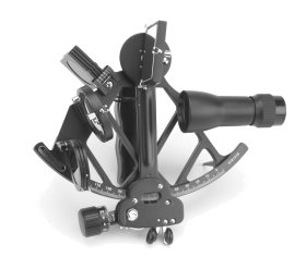
A sextant is an optical instrument used for the measurement of
angular distance between any two objects. The sextant enables
a navigator to measure the angular elevation of the sun and other
celestial bodies, and from this information the navigator can
work out his latitude and longitude.
Sun Sights - As a backup for the GPS when we are offshore
we carry a sextant. The use of the sextant goes back for hundreds
of years. The sextant is a tool that allows the user to align
the sun with the horizon to measure the angle of the sun in the
sky. Because astronomers have made very accurate tracks of the
sun's path across the sky, if we know the exact time and date,
and if we can measure the altitude and direction of the sun at
a specific time, we can establish our position in Latitude and
Longitude using special tables called "sight reduction tables"
published for just this purpose.
Once the measurements are taken, we use the sight reduction tables
to convert the data we collected to plot our current coordinates.
While this is the least accurate of the navigational methods,
we can use it when crossing long distances in the ocean, to help
us get close enough to shore to begin our dead reckoning. Because
these measurements musk be very precise, this method requires
a lot of practice to get an accurate "fix" on our location. Also,
we must have a clear view of the noon sun and the horizon to get
an accurate reading. So if the sun is blocked by clouds or the
horizon is obscured by fog or rain, this is difficult to accomplish.
Also, the sextant must be held very steady to ensure accuracy.
If the boat is heaving up and down due to large waves, getting
an accurate fix is also difficult.
Star Sights - The sextant may also be used at night by
aligning certain stars. This classic method, called "celestial
navigation," is used most commonly in the open sea. In celestial
navigation the navigator uses celestial bodies that have been
identified and grouped into constellations since ancient times.
Celestial navigation makes possible voyages across thousands of
miles of unmarked water. However, it has its drawbacks: not only
do you have all of the difficulties encountered during the daytime,
such as pitching seas, clouds, fog, rain, snow, mist, or haze
that may prevent the essential sightings of celestial bodies,
you must also be able to identify the correct stars in the night
sky.
GPS
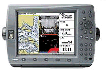
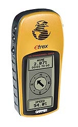
In the days of the sextant, it was very difficult to get a good
measurement on overcast days or in rough seas. The GPS works day
or night, regardless of the weather. GPS works by receiving signals
from three or more satellites in "geosynchronous" orbit around
the earth. In other words, the satellites maintain the same position
in relation to the Earth's rotation in their orbit. There are
twenty-four of these satellites in constant orbit around the earth.
The GPS receiver on the boat takes the data from these satellites
to triangulate its exact position on earth. We always carry a
handheld GPS as a backup.
For more information about using the GPS for navigation, see
the navigation methods page.
For more information about how we use the GPS on Landfall, see
the electronics page.
|
![]()