|
Routes
Plans as of Spring 2009
Well we made it to Bocas del Toro, Panama on January 13, 2008, and after a few weeks simply fell in love with the place. So much so, that we have now bought six acres of waterfront property and are building a house! Starting in this log entry describing our decision to look for property, the subsequent Ships's Logs describe our year's efforts in detail.
As of March 23, Tracy has left Panama to go to work in Iraq for a year, while Sharon holds down the fort and works on finishing up the house. So many unplanned changes! But all good ones...
Plans as of Winter 2008
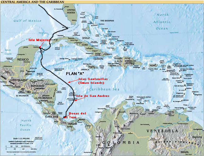
We are planning to head to Bocas del Toro, Panama, on December 2. From Isla, Bocas del Toro is about 800 miles away. We have one crew aboard, Stefan Schnur, a 38 year old German national, from Port Townsend, WA, and a really nice guy. He has been a huge help in getting Landfall ready for the trip over the last three days.
We have enough food to feed an army for weeks...and assuming the watermaker works, we can add to the 70 gallons of water in our tank, so we should be set for a while.
We will break up the trip by stopping after about 3-4 days at a small, uninhabited group of islands known as Islas Santanilla, or Swan Islands. There are no provisions or facilities in this island group, but we can at least anchor and rest for a day or two. (And celebrate Tracy's birthday!)
The next stop will be Isla de San Andrés (Columbia), a 3-4 day sail from the Swan Islands. San Andrés has food, fuel, and good anchorages. We may also visit Isla Providencia, about a day's sail north of San Andrés. The islands are a playground for Columbians and are reported to be beautiful.
Another two-three day sail should find us in Bocas del Toro, Panama in time for an early Christmas.
So, our current plan looks like this:

We are planning to sail well offshore to avoid potential interactions with people made desperate by Hurricane Felix, which ravaged the Honduran/Nicaraguan Caribbean coast border earlier this season.
Our actual float plan as of the night before leaving, if you care to chart it, is this:
Leaving Isla Mujeres Sunday Dec. 2 after taking on fuel to fill tanks and jerry jugs (112 gals. total) for direct offshore route from Punta Sur, Isla Mujeres, Quintana Roo, Mexico:
N21.12.10
W86.43.10
on heading 146° to
**Islas Santanilla (Swan Islands), territory of Honduras
Location:
N17.23.5
W083.57.00
280nm from Isla Mujeres
Expect a 3 day passage.
The weather is predicted to be gorgeous and get increasingly calmer as we head south to Islas Santanilla.
Will anchor there for a night or two (to celebrate Tracy's 51st birthday!) Then on to:
**Isla de San Andrés (Columbian territory)
N12.36.00
W081.42
about 592 miles from here; 316 miles from Islas Santanilla.
Expect a 3-4 day passage.
Expect to stay at Nene Marina in Bahia de San Andrés for a few days, maybe a week or more. Maybe even a couple of weeks after checking in, or possibly head back up to visit Isla Providencia (since it will cost at least $150 to check into Columbian territory. Should have Internet access soon after arrival and will update as soon as possible after arrival.
En route waypoints to San Andrés include avoiding the Emperor Shoal, so will target waypoint:
N16.54
W83.35.8
and then going around east of the Gorda Bank, to avoid it, so will target waypoints:
N16.00
W82.00
N15.14
W81.30.05
N14.00
W81.28
If weather is completely benign (as predicted) we may go across the Gorda Bank for a more direct route.
If weather or repairs require, or after checking into San Andrés, we may put in at Isla Providencia, about day's sail north of Isla de San Andrés, at
N13.21
W81.22
**From San Andrés southbound, will proceed directly to
**Bocas del Toro, Panama, with a waypoint heading toward the channel at
N09.28.0
W82.10.0
thence to the channel red buoy #2 at
09.22.2
82.12.7
which is about 192 miles south of San Andrés
and on through the channel markers, ending at the Bocas del Toro waterfront, or at Careening Cay Marina, just across from the Bocas waterfront on Careneros island.
Expect about a 2 day passage.
We have a satellite phone now, from Iridium. If we need to, we can access the Internet en route ($1.35 a minute--will only access for weather info!).
Plans as of Fall 2007
If you look at our plans as of Early Spring 2007, (or the world map, which isn't yet updated), you can see that we definitely have had to be flexible about our plans! As the repairs and parts lists grew while we were in Pensacola, our departure was delayed long enough that it would not have been possible to get to our hoped-for ABC islands before hurricane season started.
Our revised plan had us sailing straight from Pensacola to Key West non-stop (7 days). We waited out a number of strong weather systems in Key West, and made repairs necessitated by the long, occasionally rough passage across the Gulf of Mexico.
After almost a month in Key West, we headed straight from Key West to Isla Mujeres, Mexico, just off the northeastern tip of the Yucatan Peninsula. The passage took 4 days non-stop.
Once there, repairs to the dinghy took up a good week or two. By then, the weather in Isla was perfect and the weather in Panama was horrible. We keep staying, hoping for a weather window. Then we found a good hurricane hole on Isla, and the idea of moving on to Panama waned as our delight with Isla grew. So, we have been staying in Isla Mujeres through hurricane season 2007, and will head to Panama after Thanksgiving.
We had at one point thought we would like to be able to spend a little time in the Rio Dulce of Guatemala, especially after cruiser friends who left Isla Mujeres wrote telling us how beautiful it is. But what with one thing and another, including reports of piracy near the Honduran and Nicaraguan coasts after the hurricane there this season, we've decided to bypass that area for now.
If we had decided to visit the Rio Dulce, we would most likely have also visited one or two of the Bay Islands of Honduras (Guanaja and/or Roatan), before rounding down toward Panama. Our route would have looked more like this:

We may yet visit that area, approaching from the south after a stay in Panama this winter.
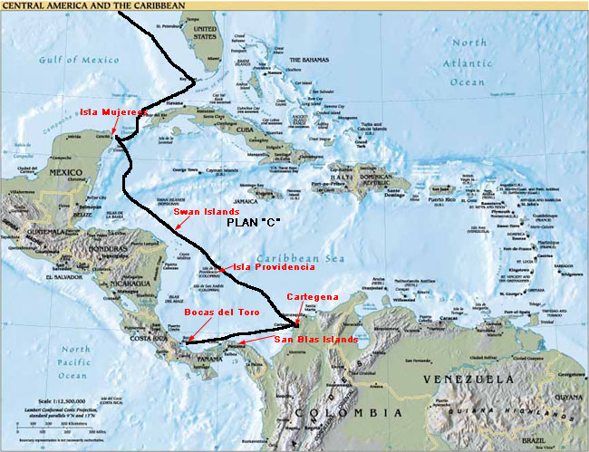
Another possible route, because of the prevailing winds and currents, could have been to sail across to Cartagena, Columbia, and then head southwest to Panama from there. We have heard such wonderful things about Cartagena; it is definitely a place we want to visit. That route would look more like this:

The winter and spring of 2007-8 should have us exploring much of Panama's Caribbean coast, including the San Blas islands to the east, and sailing possibly as far east as Cartagena, Columbia and as far north as the Rio Dulce in Guatemala.
When the timing is right, we'll head into the Canal and pop out on the Pacific side, headed for the Galapagos Islands and the South Pacific.

After the Panama Canal
We will most likely pass through the Panama Canal to the Pacific Ocean in late 2008-early 2009, and explore the Las Perlas Islands, then head north to explore the west coasts of the Central American countries. We may even get as far north as Mexico, as the area around the Bay of Huatulco has some wonderful anchorages and a vibrant native culture. Eventually, we'll head west to the Galapagos Islands.
Westward from the Galapagos Islands is a vast distance of open ocean, with the closest stop the Marquesas Islands in the South Pacific. That passage should take anywhere from 30 - 45 days, non-stop. From there, there are more than 10,000 islands in the South Pacific, so we will have some decision making to do about where to go specifically.
We plan to spend most of 2009-11 in the South Pacific, working our way west toward Australia and New Zealand, where we will likely spend 2011-12. We should cross the Indian ocean sometime in 2012 or early 2013. Depending on the political climate in the southern African countries, we'll spend more or less time there.
By 2014 we plan to cross the South Atlantic Ocean and begin exploring the countries of eastern South America. Brazil in particular offers many exciting adventures, including voyaging up the Amazon River.
Sometime in 2016 we should cross our outbound path, probably right back in Key West, Florida!
Keep in mind that our specific schedule is tentative. When we find places we enjoy, we will stay longer; when we are ready, or when the tropical weather season requires it, we will move on.
For more specific information about our adventures and to see where we've been, look at our Ship's Log. The log will contain entries of our passage-making and activities, so you can see where we've been and the conditions of wind, waves, currents and weather we encountered getting there.
Plans as of Early Spring 2007 (Written While Still in Pensacola, FL)
In the late spring of 2007, before hurricane season, we will sail to the Caribbean. Our plan is to spend the 2007 hurricane season below the hurricane belt, most likely in the islands known as the ABC's (Aruba, Bonaire and Curacao).
To get there, we will make two long hops down the western coast of Florida to the Keys, then head southeast through the Bahamas and Leeward Islands until we reach Puerto Rico and the U.S. Virgin Islands. We will head south from there, making a long jump of about 360 miles across the Caribbean to the ABCs. We just don't have enough time before hurricane season to visit the Windward islands, so we will have to explore them on our return route. As for more specifics than that, the weather will most likely make many of our decisions for us!
For the remainder of 2007 and early 2008 we will continue to explore the southern Caribbean. We will sail west toward Cartagena, Columbia, an historic and beautiful city which is also below the hurricane belt, eventually ending up in the San Blas Islands, home of the Kuna Indians and a fabulous cruising area.

After hurricane season 2007, we'll head up to the Yucatan Peninsula of Mexico and the east coast of Central America. Belize is a must-do, home of the second largest barrier reef in the world! The Rio Dulce in Guatemala is also a major attraction for us, both for its protection from bad weather, and because there is a large cruising community there, from whom we can glean lots of local knowledge about other places to visit.
We'll spend some time diving in the Bay Islands of Honduras, and visit Costa Rica and Panama. Since we recently spent time in the Bocas del Toro area of Panama, we'll catch up with some friends there, and then eventually finish our tour of the Caribbean at the entrance to the Panama Canal at Cristobal and Colon.
The Big Picture
Check out the World Map; the thin squiggly black line on the map shows a rough outline of our circumnavigation plan. See an animated version of the route, courtesy of our Key West anchorage neighbor William R. Schrack. Our routes in each specific area will also be shown on the Geography pages.
Back to top
|
![]()