|
Geography
- The Big Picture
For information about specific countries we are visiting, check out the various
country links below.
The
Blue Planet
Earth is the only planet whose English name does not derive from
Greek/Roman mythology. The name derives from Old English and Germanic.
There are hundreds of other names for our planet in other languages.
Earth, of course, can be studied without the aid of spacecraft.
Nevertheless it was not until the twentieth century that we had
maps of the entire planet. Pictures of the planet taken from space
are of considerable importance; for example, they are an enormous
help in weather prediction and especially in tracking and predicting
hurricanes. And they are extraordinarily beautiful.
Unlike the other planets planets in our solar system, Earth's
crust is divided into several separate solid plates which float
around independently on top of the hot mantle below. The theory
that describes this is known as "plate tectonics". It is
characterized by two major processes: spreading and subduction.
Spreading occurs when two plates move away from each other and
new crust is created by upwelling magma from below. Subduction
occurs when two plates collide and the edge of one dives beneath
the other and ends up being destroyed in the mantle. There is
also transverse motion at some plate boundaries (e.g. the San
Andreas Fault in California) and collisions between continental
plates (e.g. India/Eurasia).

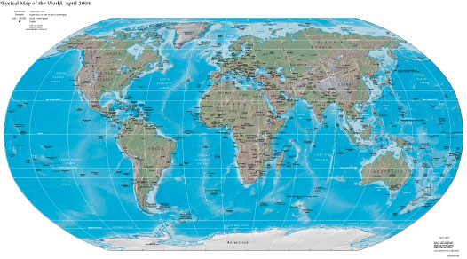
There are (at present) eight major plates:
- North American Plate - North America, western North Atlantic
and Greenland
- South American Plate - South America and western South Atlantic
- Antarctic Plate - Antarctica and the "Southern Ocean"
- Eurasian Plate - eastern North Atlantic, Europe and Asia except
for India
- African Plate - Africa, eastern South Atlantic and western
Indian Ocean
- Indian-Australian Plate - India, Australia, New Zealand and
most of Indian Ocean
- Nazca Plate - eastern Pacific Ocean adjacent to South America
- Pacific Plate - most of the Pacific Ocean (and the southern
coast of California!)
There are also twenty or more small plates such as the Arabian,
Cocos, and Philippine Plates. Earthquakes are much more common
at the plate boundaries.
The Earth's surface is very young. In the relatively short (by
astronomical standards) period of 500,000,000 years or so erosion
and tectonic processes destroy and recreate most of the Earth's
surface and thereby eliminate almost all traces of earlier geologic
surface history (such as impact craters). Thus the very early
history of the Earth has mostly been erased. The Earth is 4.5
to 4.6 billion years old, but the oldest known rocks are about
4 billion years old and rocks older than 3 billion years are rare.
The oldest fossils of living organisms are less than 3.9 billion
years old. There is no record of the critical period when life
was first getting started.
71 Percent of the Earth's surface is covered with water. Earth
is the only planet on which water can exist in liquid form on
the surface. Liquid water is, of course, essential for life as
we know it. The heat capacity of the oceans is also very important
in keeping the Earth's temperature relatively stable. Liquid water
is also responsible for most of the erosion and weathering of
the Earth's continents, a process unique in the solar system today
(though it may have occurred on Mars in the past).
The
Countries
Coastal United States
Caribbean
Central America
South America
South Pacific Islands
Australia
|
![]()